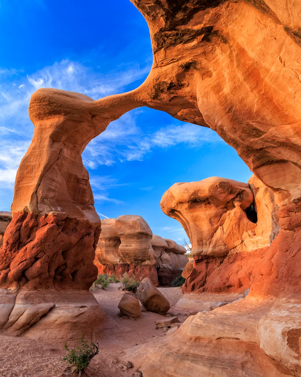
How a wild corner of southern Utah became the last place to be mapped in the US
Somewhere in the backcountry outside Escalante, a small Utah town of drive-by diners and dust devils, and down a cramped slot canyon, adventure guide Rick Green is exploring a strange frontier so wild and unknown that it remains one of the most mysterious places on Earth.
The ravine drops 30m from an apron of mountainous land to a desert floor, shrinking in width from around 100ft to barely 1ft, twisting and turning before entering a labyrinth of uncharted canyons where the rock is a streaky orange, the colour of a perfect sunset. All around, it is heavy with quiet.
With the temperature pushing an extreme 40C and the canyon providing relief from the stifling heat, Green presses on, aided by a helmet, harness, climbing rope, rappel rings and carabiners that help him descend further into the concealed valley. Beyond, there are few exits.
“No one was interested in this place for a very long time,” said Green, co-owner of Excursions of Escalante. “This is where the last range of mountains in America, the Henrys, were named. It’s home to the last-named rivers. It was the last place in America to be explored in the 1870s. Everyone kept passing it by because it was so darn dangerous.”
Today, southern Utah’s Grand Staircase-Escalante National Monument is among the most treacherous and inaccessible swathes of land in the US. It is a concertina, rippling with complicated plateaus, ridges, cliffs and escarpments that have never been fully conquered nor understood by any American, Indigenous or otherwise. It is bigger than some US states – Delaware and Rhode Island, for instance.
And, crucially, for cartographiles, it was the last place to be mapped in the continental US.
These days, Green figures there are hundreds of slot and slickrock canyons here that have never been seen by human eyes, let alone explored. Even so, he’s made a living out of surveying around 30 of the most accessible to better understand this wild corner of southern Utah. “Grand Staircase-Escalante gets canyoners like me up in the mornings,” he said. “We have the most. The most densely concentrated. And, better still, the most beautiful too.”
Seen from space, the national monument is a colossal giant’s stairway, leading from the Colorado Plateau to the Grand Canyon. Up close, it is an ancient maze of jagged walls and looming mesas. On paper, another revelation awaits. It covers a 1.87-million-acre footprint of American public lands and spans five bio-zones – from low-lying desert to coniferous forest – and absorbs the historical territories of the Anasazi and Fremont peoples.
First designated by Bill Clinton in 1996, the national monument is also an ongoing political concern. Former US President Trump decided to open up the area for development, reducing its area by half, but President Biden backtracked in October 2021, issuing a presidential proclamation modifying the boundaries and restoring its preservation order.
The original decree sets out the motive for this designation: “This high, rugged, and remote region, where bold plateaus and multi-hued cliffs run for distances that defy human perspective, was the last place in the continental United States to be mapped,” it states. “The monument has a long and dignified human history: it is a place where one can see how nature shapes human endeavours in the American West, where distance and aridity have been pitted against our dreams and courage.”
Giving credence to the declaration, historical accounts from the late 1880s explain that pioneers first forged a route from Escalante to what is now Fortymile Spring in an effort to map a shortcut to the San Juan River but were held up by excessively rough terrain. Proof, argues the proclamation, that nowhere in America was harder to overcome.
The most compelling chronicle appears in the book A History of Southern Utah and Its National Parks by Angus M Woodbury. A hardy band of scouts were sent to investigate and secure the most rugged areas of the Kaiparowits Plateau in what is now part of Grand Staircase-Escalante National Monument, but returned in disappointment having failed.
“Envoys were sent to Salt Lake City to appeal for assistance, which was given in the form of a legislative appropriation for blasting a way through,” the account reads.
For Grand Staircase-Escalante National Monument Manager Adé Nelson, the land remains both an enigma and a geographical puzzle likely never to be fully resolved. “Due to the rough and rugged terrain, there are portions of the monument that are totally unreachable and will probably never be fully mapped,” she explained.
Nowadays, these canyonlands are a frontier in an altogether different sense of the word. Researchers call it the “Science Monument” because the area has become an enormous outdoor laboratory that scientists utilise every corner of to better understand our environment, our history and our planet’s past. Cretaceous-era oyster and clam shells far from any ocean are littered on the tops of inland mountain ridges. Petrified crocodiles and three-toed Tyrannosaurus Rex footprints lie waiting to be uncovered. Like a landscape-scale natural history museum, it is filled with bones and relics.
This unique backdrop has spurred hundreds of studies in the 27 years since the monument’s designation, from investigating how the monument’s geology provides insight into the hydrology of Mars to unearthing some of the oldest marsupial fossils ever identified to discovering many previously unknown species of dinosaurs, including North America’s oldest mosasaur – a 94-million-year-old marine reptile called Sarabosaurus dahli found in June 2023.
“On average, one new species is formally recognised each year as a result of the paleontological research done in the monument,” said Megan Crandall, a spokesperson for the Bureau of Land Management, which acts as caretaker for all US public land, including the National Monument. “A T2 Tyrannosaur excavated at the Kaiparowits Formation starting in 2020 was so large that scientists struggled to figure out how to split up the specimen for transport.”
What’s more, in topography as labyrinthine as this, one might expect to find little evidence of human occupation – and yet the landscape is home to scattered examples of ancient petroglyphs, traditional campsites, burial grounds and granaries. In effect, it is a trove of Indigenous Native American culture and folklore. Indeed, in the Navajo language, the area’s mountainous backbone is still referred to as Dził Bizhiʼ Ádiní (“The mountain whose name is missing”).
Stories like this are now revealed at the Anasazi State Park Museum, which borders the National Monument in the high-altitude town of Boulder. Most remarkably, around 162,000 artefacts have been recovered so far from the site where the Anasazi – also known as the Ancestral Puebloans of the American West – once eked out an existence as long ago as 200 BCE.
“The Anasazi really survived on the edge of nowhere here,” said park manager Jamie Skidmore, who now devotes her time to giving the ghosts of the past a voice. “It’s always been a hard place to survive with lack of water and food – it’s little surprise this ancient community eventually fled because of hardship and drought.”
Today, tourism is helping to shift perspectives, and the landscape is slowly being prised open. Much of the monument remains inaccessible except on foot and a handful of trails can be found via an interactive map managed by the Bureau of Land Management’s partner organisation, Grand Canyon Trust. Slot canyons like Peek-a-boo and Spooky and trails leading to places such as Lower Calf Creek Falls and Willis Creek Narrows are where heartbeats fill heads and jaws hit the floor.
“These lands are a source of inspiration and learning for some and a source of peace, resilience and unity for others,” said Harry Barber, manager of Paria River District, a Bureau of Land Management office in southern Utah. “Each morning, I can be found somewhere on the monument, usually running or biking. I go there to sharpen my mental saw for the day ahead. As I’m out on the trail, I often see others, who I can only suspect are there for similar reasons.”
The land remains a teacher, that much is evident. And yet, it can also impart unwelcome lessons to travellers who come unprepared. Phone coverage across the monument is sparse, if at all. Juniper and pine trees sever their own branches to survive in the extreme heat. Fatalities following slot canyon flash floods are not uncommon.
It serves as a reminder that adventure – elemental, endless, unpredictable – is never far away in America’s wildest national monument.
Related posts:
 Maria Ohisalo interview: Borders, feminism and Finland’s green recovery plan
 Breaking up Southern Savonia won’t work for Centre, confirms Kulmuni
 How to spend an artsy and nature-filled weekend in St Petersburg, Florida
 Hot wheels – how wheelchair tennis became a Grand Slam draw
 Why 2024 could be the worst year ever for ‘overtourism’